Iran-Iraq Earthquakes: Understanding The Shifting Ground
The border region between Iran and Iraq is a land steeped in history, culture, and, unfortunately, frequent seismic activity. This area, nestled within a complex geological landscape, has been repeatedly shaken by powerful tremors, leaving behind trails of devastation and prompting critical questions about preparedness and resilience. The sheer force of these natural phenomena underscores the unpredictable power of our planet, demanding both scientific understanding and humanitarian response.
From the tragic loss of life to the monumental efforts in recovery, the story of earthquakes in this volatile region is one of human vulnerability against immense geological forces. This article delves into the specifics of significant seismic events along the Iran-Iraq border, particularly focusing on the devastating 2017 quake, exploring the underlying geological reasons, and examining the broader implications for the affected communities.
Table of Contents
- The Devastating 2017 Iran-Iraq Earthquake: A Closer Look
- Seismic Activity Along the Iran-Iraq Border
- Measuring the Tremor: Magnitude and Depth
- The Human Toll: Beyond the Numbers
- Response and Recovery Efforts
- Preparing for the Unpredictable: Lessons Learned
- Recent Seismic Events in the Region
- The Broader Geopolitical Context and Natural Disasters
The Devastating 2017 Iran-Iraq Earthquake: A Closer Look
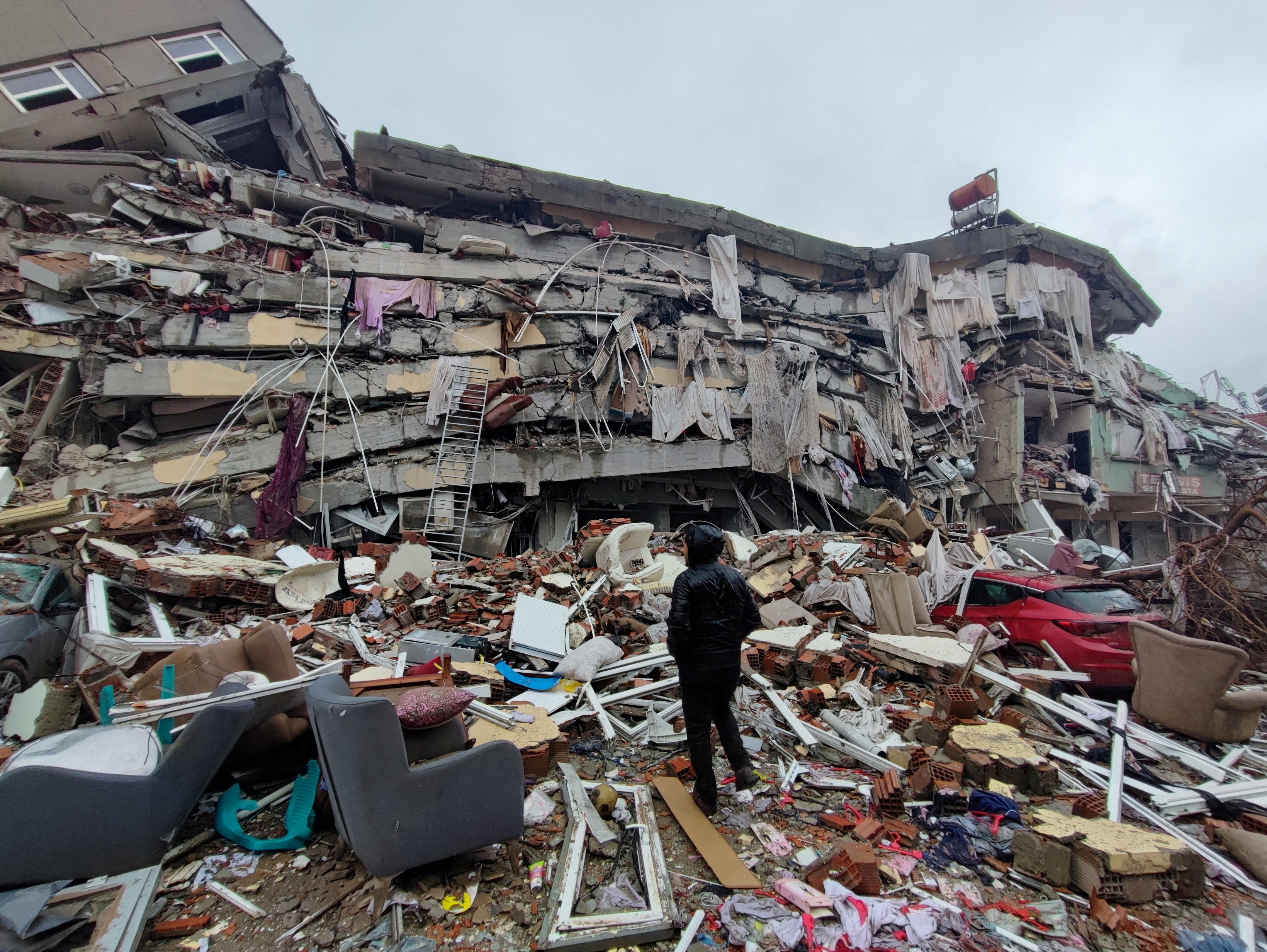
On November 12, 2017, at precisely 9:18 p.m. local time (Iran time), a catastrophic earthquake Iran Iraq border region. This powerful tremor, measuring a formidable 7.3 magnitude, struck near the Iraqi border, sending shockwaves across a vast area. The epicenter was located about 22 miles southwest of the city of Halabja in Iraq, though its impact was felt profoundly in Iran's mountainous western region, particularly Kermanshah province. This event quickly became one of the most significant natural disasters of the year, underscoring the severe seismic vulnerability of the region.
The quake's depth was recorded at approximately 23 km, a relatively shallow depth that contributed significantly to its destructive power. Shallower earthquakes tend to cause more intense shaking at the surface, leading to greater damage to infrastructure and a higher risk to human life. The sheer force of this 7.3 magnitude event meant that its impact was not confined to a small area; it resonated across both nations, causing widespread panic and destruction.
The 2017 earthquake Iran Iraq border stands as a stark reminder of nature's raw power. It wasn't just another tremor; it was among the largest ever recorded in this geologically active area. Seismologists quickly confirmed that this massive event resulted from the complex tectonic interactions beneath the Earth's surface, a topic we will delve into further to understand why this region is so prone to such devastating occurrences. The immediate aftermath saw a desperate scramble for survival and rescue, setting the stage for a long and arduous recovery process.
The Immediate Aftermath and Casualties
The immediate hours and days following the 2017 earthquake Iran Iraq border were characterized by chaos and a grim tally of casualties. Initial reports from Iranian media, including Tasnim News Agency, began to paint a devastating picture. Tragically, at least 452 people were killed, and thousands more were injured in Iran alone. Other reports indicated figures exceeding 530 deaths, highlighting the difficulty in obtaining precise numbers in the immediate aftermath of such a widespread disaster. The Kermanshah province in western Iran bore the brunt of the casualties, with at least 407 lives claimed and over 6,700 others injured, according to reports from October 12, 2017 (though the quake occurred on November 12, 2017, indicating some data might have been compiled across different reporting periods or initial estimates varied).
Across the border in Iraq, the impact was also severe, though perhaps less concentrated in terms of fatalities compared to Iran. The quake jolted the eastern part of Iraq severely, particularly in areas like Darbandikhan, where buildings collapsed and infrastructure was damaged. The human suffering was immense, extending beyond physical injuries to include psychological trauma, displacement, and the loss of homes and livelihoods. Families were torn apart, and communities faced the daunting task of rebuilding from scratch. The sheer scale of the devastation underscored the urgent need for robust disaster preparedness and response mechanisms in such seismically active zones.
Geological Context of the Quake
The 2017 earthquake Iran Iraq border was not an isolated event but a consequence of the intricate geological forces at play in the Zagros Mountains, a young and active fold-and-thrust belt. This region lies at the collision zone between the Arabian Plate and the Eurasian Plate. The Arabian Plate is steadily moving northward, pushing against the Eurasian Plate, leading to intense compressional forces. This ongoing collision results in the deformation of the Earth's crust, forming the towering Zagros mountain range and, crucially, creating numerous active fault lines.
Seismologists understand that the 7.3 magnitude earthquake was a result of this tectonic convergence. Specifically, it was a thrust faulting event, where one block of the Earth's crust is pushed up and over another. This type of movement is characteristic of convergent plate boundaries and is responsible for many of the world's most powerful earthquakes. The energy accumulated over years of slow, relentless plate movement is suddenly released, causing the ground to shake violently. The depth of the quake, at approximately 23 km, further indicates that it occurred within the brittle upper crust, where such stress accumulation and sudden release are common. Understanding this geological context is vital for assessing future risks and developing effective mitigation strategies in this highly active seismic zone.
Seismic Activity Along the Iran-Iraq Border
The Iran-Iraq border region is one of the most seismically active areas globally, a fact borne out by the frequent tremors that rattle its communities. This constant geological unrest is a direct consequence of its location at a major plate boundary. While the 2017 quake was exceptionally powerful, it is far from the only seismic event to affect the area. Data consistently shows a high frequency of earthquakes, ranging from minor tremors barely felt by residents to significant events capable of widespread destruction. This persistent seismic activity shapes the lives and infrastructure of millions residing in this geologically dynamic corridor.
For those living in the shadow of the Zagros Mountains, earthquakes are not a rare anomaly but a recurring fact of life. The cumulative effect of these quakes, even smaller ones, can weaken structures over time, making them more vulnerable to future, larger events. This necessitates a continuous focus on earthquake-resistant construction and public awareness campaigns. The history of the region is punctuated by numerous accounts of seismic events, each leaving its mark on the landscape and the collective memory of its people, highlighting the critical importance of understanding and preparing for these natural occurrences.
Historical Tremors and Frequency
The historical record of seismic activity along the Iran-Iraq border is extensive, painting a clear picture of a region constantly in motion. Beyond the devastating 2017 event, numerous smaller, yet significant, earthquakes regularly occur. For instance, recent data indicates that while there might be 0 earthquakes of M1.5 or greater in the past 24 hours in Iraq, the broader Iran-Iraq border has experienced 8 earthquakes of M1.5 or greater in the past 365 days. Looking at Iran specifically, there have been 2 earthquakes of M1.5 or greater in the past 24 hours, 4 in the past 7 days, 9 in the past 30 days, and a staggering 120 earthquakes in the past 365 days. These figures, though varying slightly depending on the exact geographical scope, underscore the consistent seismic pulse of the region.
The strongest recent earthquake of the past 10 years near Iraq, as confirmed by seismic records, was indeed the November 12, 2017, event. However, this region has a long history of powerful quakes stretching back centuries. Each major event serves as a grim reminder of the underlying geological processes. The frequency of these tremors, even those below the threshold of widespread damage, means that the ground is constantly shifting, and communities are perpetually living with the risk of a larger event. This continuous seismic activity necessitates ongoing monitoring by geological surveys like the USGS, whose event pages and PAGER (Prompt Assessment of Global Earthquakes for Response) website provide crucial information for understanding and responding to these natural hazards.
Why This Region is So Prone to Earthquakes
The primary reason the Iran-Iraq border region is so prone to earthquakes lies in its unique tectonic setting. As previously mentioned, it sits directly on the collision boundary between the Arabian and Eurasian tectonic plates. This isn't a gentle meeting; it's a forceful, continuous push, with the Arabian Plate moving northeastward at a rate of several centimeters per year relative to the Eurasian Plate. This slow but relentless convergence creates immense stress within the Earth's crust.
The Zagros Mountains, which run along this border, are a direct geological manifestation of this collision. They are a classic example of a fold-and-thrust belt, where layers of rock are compressed, folded, and thrust over one another. This process doesn't happen smoothly; instead, stress builds up along pre-existing and newly formed fault lines. When this accumulated stress exceeds the strength of the rocks, it is suddenly released in the form of an earthquake. The shallow depth of many of these quakes, like the 23 km depth of the 2017 tremor, means that the energy release occurs closer to the surface, leading to more destructive ground shaking. The combination of active plate collision, numerous fault lines, and relatively shallow seismic activity makes the Iran-Iraq border one of the world's most seismically hazardous regions, ensuring that the ground beneath remains perpetually restless.
Measuring the Tremor: Magnitude and Depth
When an earthquake Iran Iraq border strikes, two key measurements immediately come to the forefront: magnitude and depth. These metrics are crucial for understanding the potential impact and the geological characteristics of the event. Magnitude, often reported on the Richter or moment magnitude scale, quantifies the energy released at the earthquake's source. A 7.3 magnitude earthquake, like the one that struck on November 12, 2017, is classified as a "major" earthquake, capable of causing serious damage over large areas. Each whole number increase on the magnitude scale represents a tenfold increase in amplitude and approximately 32 times more energy released. This means a 7.3 magnitude quake is vastly more powerful than, say, a 5.2 magnitude tremor, such as one that struck near Semnan in Iran early Monday, which Tasnim News Agency reported at a depth of 10km.
Depth, on the other hand, refers to how far below the Earth's surface the earthquake originates. The 2017 quake had a depth of 23 km, while the smaller Semnan quake was at 10 km. Generally, shallower earthquakes tend to cause more intense shaking and greater damage on the surface because the seismic waves have less distance to travel and dissipate before reaching populated areas. A deeper earthquake, even if it has a high magnitude, might be felt over a wider area but cause less localized damage due to the greater distance from the epicenter to the surface. Understanding both magnitude and depth is vital for emergency responders to assess the potential scale of a disaster and for seismologists to understand the specific fault mechanisms at play in the region.
The Human Toll: Beyond the Numbers
While statistics provide a stark overview of the devastation caused by an earthquake Iran Iraq, the true human toll extends far beyond mere numbers of dead and injured. The 2017 quake, which was the deadliest of the year, eclipsing other global disasters, left an indelible mark on the lives of countless individuals. Imagine the terror of being jolted awake by violent shaking, the ground beneath you roaring, and buildings crumbling around you. For survivors, the immediate aftermath is often a scramble through rubble, searching for loved ones, grappling with the loss of homes, and facing an uncertain future.
Beyond the physical injuries, there is profound psychological trauma. Many who experience such events suffer from post-traumatic stress disorder (PTSD), anxiety, and depression. Children, in particular, can be deeply affected, struggling to process the sudden loss and disruption to their lives. The destruction of infrastructure, including hospitals, schools, and roads, further exacerbates the crisis, hindering rescue efforts and long-term recovery. Entire communities can be displaced, forced to live in temporary shelters, often lacking basic necessities. The loss of livelihoods, agricultural land, and local businesses can cripple economies for years, pushing already vulnerable populations deeper into poverty. The human toll of an earthquake is a complex tapestry of physical, emotional, social, and economic hardship that takes generations to fully heal.
Response and Recovery Efforts
Following a major earthquake Iran Iraq, the immediate response is a race against time. The 2017 quake saw a rapid deployment of rescue teams, both from within Iran and Iraq, and from international aid organizations. The priority was to locate survivors trapped under rubble, provide immediate medical attention to the injured, and offer temporary shelter to the displaced. Emergency services, including paramedics, firefighters, and military personnel, worked tirelessly in challenging conditions, often hampered by damaged roads and infrastructure. The USGS PAGER website provided crucial initial estimates of casualties and damage, aiding in the targeting of relief efforts.
The recovery phase, however, is a much longer and more complex undertaking. It involves not only rebuilding homes and infrastructure but also restoring livelihoods, providing psychological support, and establishing more resilient communities. In Iran, the government and various non-governmental organizations initiated massive reconstruction projects in Kermanshah province. This included clearing debris, providing temporary housing, and eventually constructing new, earthquake-resistant buildings. The challenge was immense, given the scale of destruction and the mountainous terrain. International aid played a vital role, providing financial assistance, medical supplies, and expertise. However, the path to full recovery is arduous, often taking years, as communities grapple with the long-term socio-economic impacts of such a devastating natural disaster.
Preparing for the Unpredictable: Lessons Learned
The recurring seismic activity, particularly the devastating 2017 earthquake Iran Iraq, serves as a powerful, albeit tragic, lesson in the critical importance of preparedness. While earthquakes cannot be prevented, their impact can be significantly mitigated through proactive measures. One of the foremost lessons learned is the absolute necessity of enforcing stringent building codes. Structures in seismically active zones must be designed and constructed to withstand significant ground shaking. This includes using flexible materials, reinforcing foundations, and ensuring proper structural integrity, especially for critical infrastructure like hospitals and schools.
Beyond construction, public education and awareness are paramount. Communities need to be educated on what to do before, during, and after an earthquake – "drop, cover, and hold on" being a fundamental principle. Regular drills, emergency kits, and family communication plans can make a life-saving difference. Furthermore, investing in early warning systems, even if they only provide seconds of notice, can allow people to take immediate protective action. For governments, this means developing robust disaster response plans, ensuring adequate resources for search and rescue, and establishing efficient distribution channels for humanitarian aid. The continuous monitoring by geological surveys, providing data on earthquake frequency (e.g., 120 earthquakes in the past 365 days in Iran), is also vital for assessing risk and informing long-term planning. Ultimately, preparedness is a continuous process, requiring commitment from individuals, communities, and governments to build resilience against the unpredictable power of seismic events.
Recent Seismic Events in the Region
While the 2017 earthquake Iran Iraq remains a benchmark for its devastating scale, the region continues to experience seismic activity regularly. The Earth's crust along this border is in constant motion, leading to a steady stream of smaller tremors and occasional moderate quakes. For instance, recent reports indicate that two earthquakes struck Iran early Monday, amidst ongoing regional tensions. One such quake, reported by Iran's Tasnim News Agency, measured 5.2 magnitude. It struck at a depth of 10km, approximately 37km southwest of the city of Semnan. While this event was significantly smaller than the 2017 catastrophe, it highlights the persistent seismic vulnerability of various parts of Iran, not just the immediate border area with Iraq.
The frequency data provided by seismic monitoring agencies further illustrates this ongoing activity. While Iraq itself might show 0 earthquakes of M1.5 or greater in the past 24 hours and 0 in the past 7 days, the broader picture for Iran and the border region is one of continuous seismic pulses. For instance, Iran has seen 2 earthquakes of M1.5 or greater in the past 24 hours, 4 in the past 7 days, 9 in the past 30 days, and a notable 120 earthquakes in the past 365 days. These numbers, while varying in magnitude, underscore that the ground is rarely still in this geologically active zone. Each tremor, regardless of its size, serves as a reminder of the underlying tectonic forces at play, necessitating ongoing vigilance and preparedness from authorities and residents alike.
The Broader Geopolitical Context and Natural Disasters
The occurrence of a significant earthquake Iran Iraq border is not merely a geological event; it often intersects with the complex geopolitical landscape of the Middle East. While natural disasters are indiscriminate, their impact can be profoundly shaped, and sometimes exacerbated, by existing political tensions, conflicts, and economic sanctions. The mention of two earthquakes striking Iran early Monday amid ongoing conflict with Israel, with one occurring as Israel pounded the country with repeated waves of air strikes, subtly highlights this intricate relationship. While there is no causal link between military actions and earthquakes, the timing can complicate humanitarian responses and divert resources.
In regions already grappling with political instability, economic hardship, or ongoing conflicts, the sudden onset of a major earthquake can overwhelm already strained emergency services and infrastructure. Aid delivery can become more challenging due to security concerns or political barriers. Furthermore, the long-term recovery process can be hampered by limited international cooperation or by a lack of resources due to sanctions or internal strife. This means that for countries like Iran and Iraq, which have faced various geopolitical challenges, the impact of a natural disaster like an earthquake is often magnified, making the path to recovery even more arduous and complex. It underscores the need for humanitarian aid to transcend political boundaries, ensuring that assistance reaches those most in need, regardless of the prevailing geopolitical climate.
The resilience of the people in the Iran-Iraq border region is continuously tested by the Earth's restless movements. From the devastating 7.3 magnitude earthquake Iran Iraq in 2017 to the smaller, more frequent tremors, the geological forces at play are a constant presence. Understanding these forces, preparing for their consequences, and responding effectively are paramount for safeguarding lives and fostering sustainable development in this historically rich yet seismically active part of the world.
We hope this in-depth look at the earthquakes along the Iran-Iraq border has provided valuable insights into the geological dynamics and human impact of these powerful natural events. What are your thoughts on how communities can better prepare for such disasters? Share your perspectives in the comments below, and don't forget to explore our other articles on disaster preparedness and global seismic activity for more insights.
- Israel Vs Iran On Map
- Iran Missiles
- Alutsista Iran Vs Israel
- Israel Attack On Iran
- Israel Vs Iran Casualties
/nepal-earthquake-2015-858240192-f0cb035a5cd94de98e2ac2ed0f8fe9bc.jpg)
15 Groundbreaking Earthquake Facts

Nature At Its Most Devastating: The Science Of Earthquakes
Pope saddened by 'huge loss of life' after earthquakes in Turkey and
